Emsworth's History - Fishermans Walk
!nvestigating the Fisherman’s Walk causeway
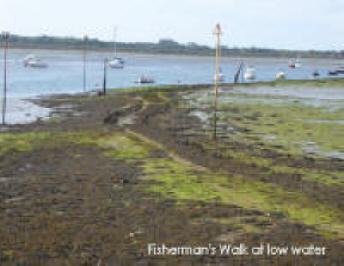
Fisherman’s Walk is a 340m long causeway (Fig 19) snaking from Emsworth to Fowley Rithe but stopping short of Fowley Island. On the first edition Ordnance Survey map of 1866 it is marked ‘Westwood’s Road’.
Archaeologists from Maritime Archaeology investigated the causeway by examining historic sources, such as maps – a ‘desk-based assessment’ – followed by a field survey in advance of limited repair works on the surface of the causeway. The map evidence proved useful for dating the causeway. Sheringham’s chart of 1848 depicts the causeway, but Greenwood’s map of 1826 does not, suggesting the causeway was constructed some time between these two dates. Fowley Island is featured on Milne’s 1791 map and subsequent maps.
The causeway seems to be linked to the oyster industry, although there is no direct evidence of this until 1885 when the Fowley Island Oyster Company was formed. The 1866 Ordnance Survey map shows oyster beds at the northern end of the causeway, and the 1898 OS map shows two oyster beds on Fowley Island. The harbour’s oyster industry collapsed in the first half of the 20th century, but the causeway seems to have been used for other purposes: on the 1952 OS map salterns are marked on its western side, and ‘Perch’ is annotated on its eastern side, perhaps referring to poles to help manoeuvre boats or secure them to.
None of the maps shows the causeway extending all the way to Fowley Island. It may have been possible to traverse the gap between the end of the causeway and the island by foot since it was colonised by eel grass that would have provided enough support to walk on. As the eel grass declined over the last 60 years, erosion of the upper firmer layers of this area increased making such a crossing impossible today.
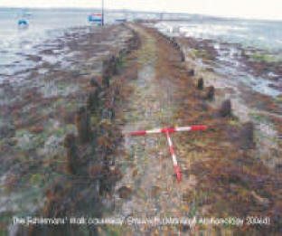
Oral evidence suggests that fishermen used the causeway to haul their vessels through the Emsworth Channel with ropes (‘warping’). This may explain the modern name of the causeway. The field survey included a photographic record of the causeway that was also mapped with a Global Positioning System. The survey revealed that the causeway consists of a semi-compacted gravel surface with some concrete slab edging, installed in the 1980s, and earlier timber batons held in place by pairs of timber pegs. Erosion has revealed details of construction, including the use of branches to form a surface.

  |
From: UNCOVERING THE PAST Archaeological discoveries in Chichester Harbour AONB 2004–2007, Published 2007 Chichester Harbour Conservancy

